Improving wayshowing systems
in walking/jogging trails
INTRODUCTION
BACKGROUND
When I’m on a jogging trail, I often feel frustrated with the information (or lack thereof) that is meant to guide me along certain trails and distances. Sometimes I have started on one trail and suddenly finding myself on a different one. I decided to dig into this problem and possible solutions through a university project.
Through this project I came up with an information system that would be more user-friendly, allowing joggers to enjoy their run effortlessly without focusing too much on finding the right way, minimizing the risk of getting lost or losing their trail.
RESEARCH
QUESTIONNAIRE
I started by creating a questionnaire to find out if the problem I had identified was recognized by others, and if so, what experience they have, what problems they tend to come across in jogging trails, what information is usually available and what information they would like to have access to. The questionnaire was answered by 129 people.
The results showed that an overwhelming majority found the information in jogging trails to be lacking. A total of 92,3 percent answered that they had felt uncertain about the way when they were on a running trail, and 76,7 percent answered that they had accidentally ended up on the wrong rail on one or more occasions. 93 percent would like to access information along the way to tell them how far they have come or how far they have left on their chosen distance, and 85,3 percent stated that color coding was the wayshowing system that they are most familiar with in jogging trails. Finally, in an open comment option, it was stated by several that maps would be useful to show where they are along the trail, and that information would be useful in more places along the trail than the main starting point, as the trail is not always started from that point.


THINK-ALOUD PROTOCOL
I proceeded by making a retrospective think-aloud protocol to gain a deeper understanding of the specific situations where problems occur. With five participants, at five separate occasions, I had each participant jog along a 3 km trail while I was jogging a few meters behind and recording. Immediately afterwards we watched the video and the participant commented on their experience throughout the video, explaining their actions and thoughts, why they chose certain paths, at what points they felt unsure about where to go and what made them feel unsure, and at what point they perceived the choice of path as obvious, and why.
My conclusion was that the width of a path is not necessarily a strong indicator of the right way. I found that wayshowing was necessary at any place where an alternative path was available. I also found that the indicators need to be available in immediate proximity to any turn, even just a few meters ahead creates uncertainty as the jogger has to actively search for the indicator. Also, indicators should be on both sides of the path as to make a ”gate” onto the right path.
DESIGN
SCENARIO
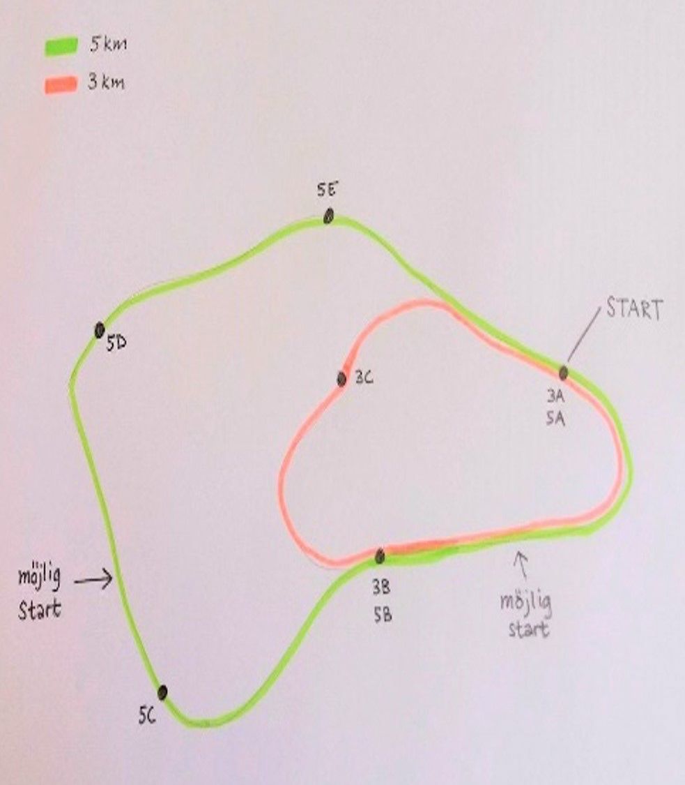
To work out a satisfying information system I made a simple drawing of a trail map with two different trails (3 km and 5 km), with one main starting point for both trails and a few alternative starting points. With this map, I tried out several different scenarios that a jogger might be in and eventually came up with an information system that would work no matter where you start, which trail you are on or in which direction you choose to follow the trail.
SKETCHING
According to the findings in the questionnaire and the think-aloud protocols, three components were found to be helpful to joggers: the trail identification (e.g. 5 km trail), enhanced by color coding, a map showing where on the trail the sign is located and finally some indicator of how far you have come, or have left. I decided to use letters to indicate the positions on the map, as to not confuse it with km numbers, as the map needs to work no matter which direction you’re running in. With five positions marked on the map, with five letters (A-E) the jogger can identify each interval as 1 km. On a 3 km trail, there would be three positions (A-C).

CONCLUSION
These signs, together with wayshowing indicators along the entire trail according to the findings in the think-aloud protocols, would give the jogger a more pleasant time on the trail without worries about finding the right way, and a more efficient way to calculate the distance gone and remaining. This system would of couse be tested, had the time of the assignment allowed for further iteration, and the system and signage design would undergo further iteration until a satisfying result was met.
